|
|
Post by jstampfl on Dec 26, 2004 17:31:32 GMT 3
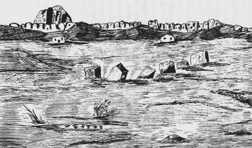
Here is a map I drew of the Orkon River Valley. This is, according to Juvaini, the area the Uyghurs believed was their ancestrial home. They built their capital Xar Bulgas ( Qara Bulgasun). Also the Mongols built Xar Xorin (Khar Khorin). But as the map shows, there are many other ruins in the area. I don't know the identity of the other cities. They could be: Turk, Uyghur, Khirgiz, or Khitan. This is now a page with several maps and images. www.blueskymongolia.info/maps/map.htmlThese are of the ruins number 4 on the map, the locals say Ogedei Khan used this area as his summer camp. Has a nice Hot Mineral Spring nearby. www.blueskymongolia.info/images/p11b.jpgwww.blueskymongolia.info/images/p13.jpgThese are ruins number 13. This city was constructed of stone. Now just stones strewn across the steppe. The first photo is towards the E and the second is towards the NW in the direction of ruins number 3 on the map. www.blueskymongolia.info/images/p6.jpgwww.blueskymongolia.info/images/p8.jpg |
|
|
|
Post by H. İhsan Erkoç on Dec 26, 2004 21:07:50 GMT 3
|
|
|
|
Post by snafu on Aug 24, 2006 22:51:40 GMT 3
I've read that the Uighurs had 3 cities in Mongolia. Is there anything left of the other two?
|
|
|
|
Post by H. İhsan Erkoç on Aug 24, 2006 22:57:24 GMT 3
We can give you more information about them if we can know their names and their locations.
I only know Qara Balghasun.
|
|
|
|
Post by snafu on Sept 4, 2006 8:01:01 GMT 3
This site is in Japanese, but it shows the ruins of a second Uighur town called Baybalik, further north in the Selenga valley. homepage2.nifty.com/i-love-turk/uigur/bajbalyk/bajbalyk.htmTamim Ibn Bahr, the only traveler to visit and describe the Orkhon Uighur kingdom also mentions three Uighur towns. I'd love to read Bahr's full account, but I don't think it's ever been translated to english. |
|
|
|
Post by tadamson on Sept 5, 2006 17:29:56 GMT 3
I've read that the Uighurs had 3 cities in Mongolia. Is there anything left of the other two? I thought that the last count was 20+ |
|
|
|
Post by snafu on Sept 6, 2006 14:01:18 GMT 3
20+ cities in Mongolia? Did the Uighurs really build that many towns?
|
|
|
|
Post by H. İhsan Erkoç on Sept 6, 2006 21:52:38 GMT 3
Well, Tamim Ibn Bahr talks about a large area of Uyghur and Soghdian settlements, saying that he traveled through urban areas for 20 days (if I remember correct). Of course the number must have been exaggarated, but it shows us that Mongolia of the Uyghur Period contanied perhaps more settlements than we think.
|
|
|
|
Post by snafu on Sept 8, 2006 22:46:22 GMT 3
Is any of the architecture of the cities described? I'm curious whether the Uighurs of that period were more influenced by Sogdian or Chinese culture. Judging by what few ruins are left it looks like their cities were more along Chinese lines.
|
|
|
|
Post by H. İhsan Erkoç on Sept 9, 2006 10:37:35 GMT 3
There are records of Qara Balghasun being styled in both Soghdian and Chinese types, but I do not remember which type had the heavier influence.
|
|
|
|
Post by tantalus on Jan 7, 2007 3:04:30 GMT 3
Here is a map I drew of the Orkon River Valley. This is, according to Juvaini, the area the Uyghurs believed was their ancestrial home. They built their capital Xar Bulgas ( Qara Bulgasun). Also the Mongols built Xar Xorin (Khar Khorin). But as the map shows, there are many other ruins in the area. If you download the pdf called "The Ancient City of Kharakhorum" which I posted in this thread there is a section called "Important Sites Around Kharakhorum" and under it is a section called "Khara Balghasum". It gives the location and some history of Xar Bulgas / Khara Balghasum / Qara Bulgasun. |
|
|
|
Post by tantalus on Jan 7, 2007 5:01:59 GMT 3
Also, looking at jstampfl's map from his first post: jts88.com/maps/largeimages/Uyghur.gifAnd also reading in that same The Ancient City of Kharakhorum .pdf above, there is a section called "The Discovery of Small Surrounding Palaces". It says that Ogodei Khan built a palace called Gegen-chaghan located at Doityn Balgas, approximately 40 kilometers to the north of Kharakhorum. Which is on that map as #10, Doylyn Balgas. (Correct? Is Doityn Balgas the same as Doylyn Balgas?) ( jstampfl - Can you post a distance scale for the map?) Then the pdf goes on to say that there is also a palace of the Khans called Ormektu or Shira-Ordo, located at the junction of the River Orkon and it's tributary Bayab-gol. The junction is 15 kilometers northwest of Kharakhorum. On the map, if Doityn Balgas #10, is 40 kilometers north of Kharakhorum #1, and if Ormektu Palace, is 15 kilometers north of Kharakhorum #1, then either #3 or #13 on the map is the Ormektu Palace. The only problem is I don't see a tributary, the Bayab-gol, at that spot. Maybe it is too small for the map. The pdf also says that there was another palace built by Ogodei Khan in the Valley of Tsarkhain-gol, approximately 20 kilometers south-southeast of Kharakhorum. This may be #20 on the map. This palace was called Tuzghu-Balyk. |
|
uyghur
Är
 essalamu ,eleykom
Posts: 15
|
Post by uyghur on Oct 29, 2007 16:00:26 GMT 3
thank u
|
|
mwe
Är
Posts: 30 
|
Post by mwe on Nov 12, 2007 4:40:44 GMT 3
To store gold, silk, silver and other valuable stuff.
|
|
|
|
Post by uyghurogli on Nov 14, 2007 22:07:11 GMT 3
Is it of Karabalsagun or Karakorum?
|
|